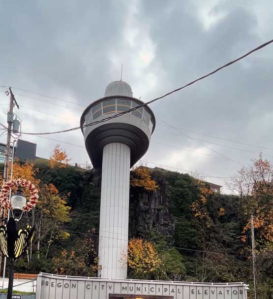
The Oregon City Municipal Elevator is a unique landmark with fantastic panoramic views and overlooks Willamette Falls. The history of Oregon City is also beautifully featured inside with holographic images that change and show multiple images of the timeline changing. There are also steps that you can take to get up to the top if you prefer, and these meander by the waterfall designed into a town art sculpture. From the top you can meander along a trail that winds you down to OR 99E near the Willamette Falls viewing pull off so that you can get even closer.
If you take the steps / trail from the bottom of the Municipal Elevator to the top, you end up very close to the McGloughlin House and more National Park Service Historic Sites (under Fort Vancouver).

Off road bicycle and hiking trails in Oregon City
Newell Creek Canyon Nature Park provides some trails dedicated to bicycles only, some shared bicycle and hiking, and some hiking only options. They provide a handy map that you can carry and easily find your way around the network trails.
Newell Creek Canyon Nature Park
485 Warner Milne Rd, Oregon City
They host some excellent huge events from time to time, and provide daily history presentations, tours.
Walking and Riding a Bicycle in Oregon City
While Oregon City is a charming and rich cultural historic city, it isn't the easiest to navigate as a pedestrian or on a bicycle. However, with the Trolley Trail you can make more connections and even connect all the way from downtown Portland to Oregon City with long segments on trails that are car free. The Trolley Trail gets you close to Oregon City, making the rest of the connection is not as easy on foot or bicycle.
There's also another park you can connect with to get more steps or continue your bike ride, Newell Creek Canyon Nature Park. It's not a huge park for cycling endeavors but for kids it should be pretty fantastic, or if you just want a good day exploring on your bike, it's pretty fun to explore Oregon City and this is a great place to linger.
Oregon City isn't the easiest for driving cars on the town roads either, partly because Oregon City is surrounded with several busy state highways and the huge Interstate 205 Abernathy Bridge as well as the local Oregon Highway 43 bridge crossing over to West Linn, Dunthorpe and Lake Oswego. Partly also because it is such an old historic town with beautiful old houses and buildings, the roads and first developments here were not for cars and trucks. Oregon City sits on the edge of the Portland Metro and has a feel of part city but also, opening up to the beautiful open farms and wild scenic areas and the spectacular Willamette River and Willamette Falls.
*data from ODOT Crashes by City
| YEAR |
TOTAL CRASHES |
PEOPLE INJURED |
FATAL CRASHES |
INTERSECTION |
| 2021 |
359
|
329
|
1
|
172
|
| 2020 |
325
|
220
|
0
|
166
|
| 2019 |
485
|
381
|
3
|
217 |
| 2018 |
517
|
391
|
3
|
233
|
| 2017 |
620
|
417
|
3
|
287
|
| 2016 |
676 |
462 |
2 |
311
|
Many of these motor vehicle accidents occur at intersections, often where a state highway intersects with a local Oregon City busier road (like Beavercreek Road / Molalla Avenue, or intersections with OR 99E). In addition to the crashes at Intersections, there is another category of what Oregon Department of Transportation (ODOT) calls, "Intersection Related," which isn't surprising because these are huge intersections on highways, sometimes multi-lanes and wide sections of roads. Looking further into the data, many of the fatalities are pedestrians at some of the same most dangerous intersections in Oregon. The majority of fatalities are pedestrians, people walking on foot.
The Safety Priority Index System (SPIS) is used in Oregon by the Department of Transportation for reports on state highways. This is the page with reports for off Oregon state highways Safety Priority Index System (SPIS).
The SPIS is a
systemic scoring method that identifies potential safety problems on state high-ways. The SPIS score is based on three years of crash data and considers crash
frequency, crash rate, and crash severity. A highway segment becomes a SPIS site
if a location has: 1) three or more crashes OR; 2) one or more fatal crashes, over
the three-year period.
"In 2013, Oregon’s 60 most dangerous intersections generated nearly 3,400 accidents, resulting in 56 deaths and more than 1,800 injuries. "
#6 in 2013: OR-213 & Beavercreek Rd.
Oregon City, Clackamas County.
Total Crashes: 92
Fatalities: 1
Injuries: 51
Property Damage: 40
#15 in 2013:
OR-99E & Dunes Dr.
Oregon City, Clackamas County.
Total Crashes: 82
Fatalities: 1
Injuries: 44
Property Damage: 37
#44 in 2013:
OR-213 & Mollala Ave.
Oregon City, Clackamas County.
Total Crashes: 23
Fatalities: 1
Injuries: 9
Property Damage: 13
These above three intersections were identified as some of the most dangerous in Oregon in 2013 continue to be some of the most dangerous. The most recent SPIS report in 2021 utilized data from 2018 - 2020 which shows Oregon City continues to have many roads and intersections on the highest crash rate in the state, Beavercreek Road OR-213 as well as Dunes Drive OR-99E remain notable for very high crash rates.
 Emily Hsu


